


When you are a service provider with high client expectations, you need to be able to obtain quality results on a regular basis. When it comes to agriculture, producing consistent index maps is critical, regardless of weather conditions. If you try to investigate whether the pesticide treatment is working or not, you need to be sure the two maps you are comparing show the difference on the plant’s health, not the weather conditions.
This is the plight of Spanish company Technidrone, which assembles specialized drone systems and provides mapping services in agriculture, thermography, surveying and more. When the Parrot Sequoia multispectral camera was released, they were among the first to use it. They pushed the product limits and even designed and freely shared the sketches of a 3D printable mount we could now say is the standard for Sequoia/drone integration.
Multispectral Imagery for Monitoring Plots over Time
For one job, Technidrone was hired by a reputable company to fly over several experimental plots in northern Spain – the famous Pamplona of Navarra. The plots were experimental, but the data was not: Technidrone captured multispectral imagery of the plots over time for monitoring, for example, the different plant varieties and the fertilizer application techniques and quantities.
For this work, Sequoia was mounted on the Aeris Pro drone. This drone, designed and manufactured by Technidrone, weighs 5 kg and can carry up to 1 kg in sensors. And at 30 minutes, the flight time is solid.
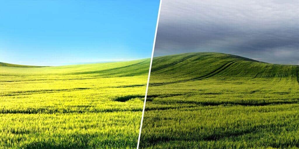
The Aeris Pro flew two days in a row with Sequoia. Because the goal was to use the data to monitor plots over time, the flights were planned identically. The weather, however, was different on both days: The first day had clear skies, and the second day was overcast.In order to have the dataset georeferenced and to get survey-grade accuracy, Technidrone added seven ground control points into Pix4Dag at no charge.
 In order to have the dataset georeferenced and to get survey-grade accuracy, Technidrone added seven ground control points into Pix4Dag at no charge.
Before flying, Technidrone’s team used a reflectance calibration target. Acquiring images to calibrate the target helps during processing; the goal is to obtain absolute reflectance values.
Notably, they were careful not to cast any shadow over the target when taking pictures – which would produce skewed results for the whole project.
For processing data, Technidrone used Pix4D. Surveyor Daniel Pablo said, “This was a no-brainer because currently Pix4D is the only processing software out there that allows us to leverage the sunshine sensor.”
Sequoia’s sunshine sensor collects irradiance data and corrects for illumination differences while the drone flying. In other words, it allows you to fly in almost any weather condition – sunny or not – and get comparable results.
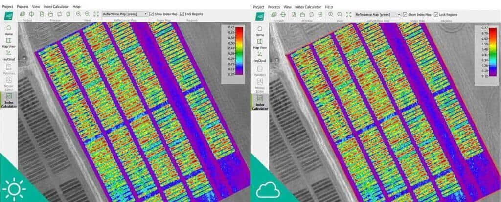
Below, you can see the end results. The map on the left was produced from data taken on a sunny day, and the map on the right was produced on an overcast day. The results are nearly identical, and it’s actually quite difficult for the human eye to detect any differences that exist.
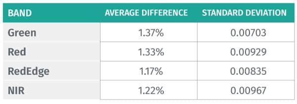
Tecnidrone has also shared a small statistical analysis on how similar the results from both weather conditions were.
The table below shows the average difference and standard deviation for the reflectance maps in both scenarios.
For Technidrone, the results were a big deal: As a service provider that conducts high-level jobs, the company was able to obtain the same index maps regardless of mother nature.
The article is adapted from a blog post by Pix4D, a Switzerland-headquartered developer of drone mapping software.


