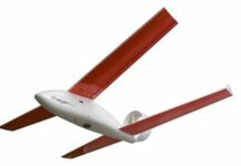
Swiss mini-drone manufacturer senseFly has launched the eBee RTK unmanned aerial vehicle (UAV), which the company says is the only fully integrated, fully compatible, survey-grade mapping system on the drone market.
The vehicle, which will be available in the third quarter, will offer surveying and engineering professionals an accurate and flexible mapping solution that works alongside their existing base stations and does not require any third-party software, senseFly explains.
The company says the eBee RTK features an integrated GNSS receiver with RTK functionality and is supplied as standard with two software packages: eMotion 2 flight planning and control software, and Postflight Terra 3D professional photogrammetry software (powered by Pix4D).
In addition, the entire aircraft weighs about only 1.5 lbs – which, in turn, minimizes its power usage and allows it to be hand launched (no accessories required), ensuring the safety of people and objects on the ground, senseFly notes.
With a maximum flight time of 40 minutes, the UAV uses its 16 megapixel still camera to photograph areas of up to about four square miles in a single flight.


