AirMap has joined forces with Airways New Zealand to deploy an unmanned traffic management system (UTM) for a three-month trial in the Canterbury and Queenstown regions of New Zealand.
According to AirMap, as drones take off in increasing numbers in New Zealand, UTM technology will allow them to integrate safely into New Zealand’s airspace.
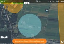
The Airways-AirMap trial introduces digital authorization capabilities deployed in the U.S. for the Federal Aviation Administration’s trial LAANC program. Using AirMap’s free iOS and Android apps, drone operators can request airspace approvals required by New Zealand’s Civil Aviation Authority. Digital authorization is available from the Christchurch, Queenstown and Wanaka airports and on public lands in the Christchurch City, Selwyn and Queenstown Lakes District Councils, including parks and reserves. Commercial and recreational drone operators are invited to take part in the trial, which is currently underway, says AirMap.
Airspace managers participating in the trial are using the AirMap airspace management dashboard to provide digital flight authorizations and share real-time updates about the location of events, community gatherings, emergencies and other areas to avoid. This information is delivered immediately to the AirMap app to enable safer flights and more comprehensive situational awareness, the company says.
“The trial is an important step in investigating how Airways could develop a nationwide UTM system that safely integrates UAVs into New Zealand’s wider air traffic control network,” says Graeme Sumner, chief executive of Airways. “There is potential for New Zealand to become a test bed for the UAV industry through the implementation of a system that supports growth and development in a safe manner.”


