3DR, makers of Site Scan, a drone software platform for construction and engineering professionals, has released 3DR GCP, an Android app enabled by the Trimble Catalyst on-demand global navigation satellite system (GNSS) service.
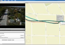
According to 3DR and Trimble, the new app makes it simpler for Site Scan users to capture and use ground control points (GCPs) on commercial drone projects. Now, instead of having to export GCP data files and manually upload them into Site Scan, 3DR customers can use 3DR GCP to quickly capture GCPs and automatically transfer them to their corresponding projects in the Site Scan cloud for georeferencing and processing.
The Trimble Catalyst uses a small, lightweight, plug-and-play digital antenna to deliver satellite data to the 3DR GCP app running on the user’s Android device. The service is available as a monthly subscription, which unlocks a range of precision levels, from meter to only a few centimeters. Customers go on-site, plug the Catalyst DA1 antenna into their Android device, launch 3DR GCP, and capture GCPs at the level of accuracy enabled by their Catalyst subscription.
“3DR GCP provides our customers an end-to-end, cloud-based ground control point workflow from the field to the office,” comments Chris Anderson, CEO of 3DR. “With this app, we’ve closed the loop on ground control points by making one simple, connected workflow from start to finish.”
“Trimble is excited for 3DR to join our ecosystem with the launch of 3DR GCP,” adds Gareth Gibson, business development manager for Trimble Catalyst. “With this innovative ground control app, 3DR is making it easier than ever for their customers across the world to create accurate, reliable drone maps and models and better capture their projects.”
3DR GCP can be purchased along with Site Scan subscriptions. It will require a Trimble DA1 antenna and Catalyst subscription.


