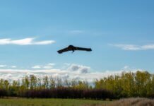
Delair, a France-based supplier of drone solutions for commercial industries, recently introduced the Delair DT26X LiDAR unmanned aerial vehicle (UAV), a long-range, fixed-wing drone that combines LiDAR sensing capabilities with an integrated, high-resolution RGB camera.
According to Delair, aerial-based LiDAR allows for extremely detailed and accurate collection of elevation data of the ground – even in large and vegetated areas – but it is typically performed with specialized, single-function platforms or expensive, manned aircraft with long lead times. In addition, camera-enabled drones offer a complementary solution for collecting imagery to augment the LiDAR-based models.
Most projects, therefore, require multiple mapping flights and separate UAVs, the company says. However, the Delair DT26X LiDAR’s combined payload of a lightweight sensor and integrated camera allows for the acquisition of LiDAR and photogrammetry data in a single flight – in turn, reducing costs and immediately providing a detailed digital model of inspected assets. Applications include environmental and land surveys, forestry monitoring, infrastructure surveillance, power line and pipeline inspections, and road and rail construction.
Delair notes the LiDAR sensor is specifically designed for UAV use; it adds little weight or bulk. Furthermore, the fully integrated RGB camera enables real-time camera sensor control and in-flight photo review with automated quality checks.
According to the company, the new platform delivers increased accuracy in 3D mapping and modeling of terrain and corridors in challenging physical environments (e.g., mountainous or inaccessible by road/foot) and with difficult visibility, lighting or weighting conditions. Its long-range capabilities facilitate coverage of up to 2,400 square acres, a communication range of 30 kilometers and 100 minutes of flight time, says Delair.
The company notes the Delair DT26X LiDAR is the first fixed-wing UAV to incorporate the new RIEGL miniVUX-1DL LiDAR sensor. The sensor includes a downward-looking and optimized field of view specifically geared for corridor mapping tasks. The wedge prism scanner construction produces a field of view of 46 degrees, and the circular scan pattern provides a very high point density and point distribution. Moreover, it offers a high scan speed of up to 150 scans per second and a measurement rate of up to 100,000 measurements per second. It is also effective in penetrating poor lighting conditions or dense foliage. The LiDAR sensor makes use of RIEGL’s unique Waveform-LiDAR technology, allowing echo digitization and online waveform processing. It also supports multiple-target resolution – up to five target echoes per laser shot.
“The combination of a sophisticated LiDAR sensor and an industrial-grade RGB camera removes the ‘either/or’ decision of choosing between LiDAR and imagery data acquisition for geospatial professionals. This is the most versatile and cost-effective UAV solution for large-area, long-range mapping and surveying where accuracy and detail are required,” says Chase Fly, geospatial product manager at Delair. “It provides the precision and visibility required by the most demanding use cases and allows data acquisition and advanced digitization not possible through terrain-based or satellite 3D mapping techniques or with limited, short-range UAVs. With this configuration, users can acquire all the data required for a colorized point cloud from a single flight, which eases the point cloud classification process back in the office, saving significant time and money.”


