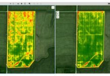
Minneapolis-based drone software company Sentera has released its NDVI Toolbox for AgVault – a set of tools for customizable normalized difference vegetation index (NDVI) data in order to give growers and agronomists more insight into field and crop health.
The toolbox, now available with Sentera’s AgVault Pro and Viewer licenses, allows users to recolor, regenerate and highlight areas of an NDVI crop health map on both current and historical data.
NDVI essentially compares one area to another, illustrated with color. If a crop is generally healthy, it appears bright green on an NDVI map. Now, Sentera says its toolbox makes that general data actionable by building flexibility into the color map. Instead of blanketing an NDVI map with a low variation of a single color, the NDVI Toolbox allows users to force dramatic color variations at a granular level to show a plant’s health relative to others in the field, the company explains.
AgVault’s NDVI Toolbox features two viewing options: day-to-day, in which growers can monitor and compare a field over time by highlighting changes from one day to the next, or acre-to-acre, in which growers can determine the overall vigor of a field, identify problems and take action.
“Until now, you needed to choose between viewing data tailored for NDVI progression over time or tailored for NDVI contrast around a single flight, but you couldn’t do both,” explains Greg Emerick, executive vice president of Sentera. “We changed that. Now, growers and agronomists have that flexibility. They are more in control of their operations and can make even better decisions even faster.”


