Categories :
 senseFly is rolling out its next-generation fixed-wing drone for survey-grade photogrammetric mapping, the eBee Plus.
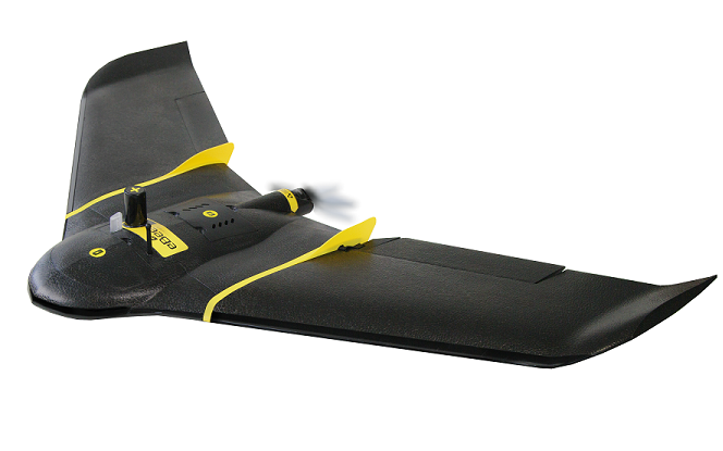
The fixed-wing drone features an elongated windspan for stable, long-duration flights of close to one hour. Additionally, it can document 220 hectares (540 acres) in a single flight (at 122 meters/400 feet in altitude) – a larger area on one battery charge than any other fixed-wing drone in its weight class, according to senseFly.
In addition, a compact senseFly S.O.D.A. sensor – senseFly’s proprietary, high-resolution RGB camera – features a 1-inch sensor and global shutter and is capable of capturing images with a spatial resolution of 2.9 cm (when flying at 122 meters [400 feet]).
The drone also includes the eMotion 3 flight and data management software, a ground station featuring the full flight in 3D, mission block flight planning and cloud connectivity.
senseFly says the eBee Plus features High Precision on Demand, which describes the drone’s built-in upgrade path to real-time and post-processing correction (RTK/PPK) functionality. Once activated by the user, the paid enhancement boosts the system’s achievable horizontal/vertical absolute accuracy without the need for ground control points – in turn, reducing expensive, time-consuming field work, says senseFly.
The eBee Plus can carry the full line of senseFly fixed-wing RGB, thermal and multispectral sensors, including the recently introduced Parrot Sequoia for agricultural work and the thermoMAP for producing thermal maps. The drone’s camera bay also accepts existing eBee payloads, while the senseFly S.O.D.A. is itself backward-compatible with operators’ existing eBee and eBee RTK drones.
“The eBee Plus system is the ultimate tool for geospatial organizations that demand photogrammetric-quality mapping,” says senseFly’s CEO, Jean-Christophe Zufferey. “With its unique upgradeable RTK/PPK functionality and flight time of almost an hour, this simple, largely automated solution is perfect for professionals working in fields such as surveying, construction and GIS who require a highly efficient method of data collection with survey-grade accuracy.”
The system is available to order immediately via senseFly’s global network of distributors. The company plans to officially unveil the aircraft at INTERGEO 2016 on Oct. 11 in Hamburg, Germany.